
This is a lovely walk, full of interest and with a few surprises. For instance, between Whitehouse Farm and Island Pool there is a totally unexpected landscape - a shallow valley with gorse, bracken, scrub, masses of rosebay willowherb and patches of wetland.
It looks like common land but isn't designated as such. However, according to the Wolverley and Cookley Historical Society, it was formerly common land, part of the much larger Caunsall and Broadwaters Common, a victim of the Inclosure Act of 1778. It seems almost miraculous that this small oasis of wildlife-rich country should have been enclosed and yet escaped cultivation or grazing.
There are masses of thistles along the path from Whitehouse Farm, which might not sound too appealing, but thistles are great for wildlife. Butterflies feed on their flowers in late summer, but at this time of year it is their seeds that are in demand, particularly among flocks of goldfinches. Another name for a goldfinch flock is a charm' and few people familiar with these little birds with their multicoloured plumage (black, brown, yellow, white and red) would quibble with that.
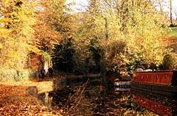
Other colourful birds which you may see on this walk include jay and green woodpecker. As for mammals, the squirrel is the one species you're almost certain to see. They're everywhere, but especially active in a copse of sweet chestnut trees between Wolverley and Debdale Farm. You'll pass two pools on this walk - Ismere Pool and Island Pool. The latter is one of a chain of four which were harnessed to provide power for Sleepy Mill, a corn mill which operated from the 1600s until 1908. It is now a private house, situated 300m to the north of Island Pool, beside Wolverhampton Road.
DIRECTIONS1 Walk north through Wolverley village, passing the Queen's Head and the shop. Keep straight on at a road junction then turn right along The Shortyard, which leads past houses to become a track across a field. Keep straight on at a junction by a corrugated-iron building. After passing under some sweet chestnut trees enter another field and continue along the edge to a fence corner where a waymark directs you towards Debdale Farm.
2 As you reach the farm ignore a misleading waymark and go left along the farm track, skirting to the left of most of the buildings. Turn right at the next junction, cross the River Stour and proceed to the Staffordshire and Worcestershire Canal. Turn left on the towpath.
3 Go up to a road at Caunsall Bridge and turn right. Cross Wolverhampton Road (A449) and walk for 100m along the lane opposite until you can join a path on the right. Go diagonally left across a field towards a farm. A hedge gap gives access to a lane and the path continues opposite, through a bungalow garden and then through a gate to a field. Turn left alongside a fence then through a gap into the next field. Go diagonally across to the far side then along the edge of another field to Whitehouse Farm and Ismere Pool.
4 Turn right through a new gate to join a fenced path which is initially narrow, uneven underfoot and overgrown - be careful not to end up in the adjacent ditch. Keep straight on at any junctions, eventually passing through woodland by Island Pool to meet Wolverhampton Road. Cross over, turn right past the Cookley Arms, then turn left along a lane.
5 Turn left on a bridleway at Broadhouse Farm Nurseries. Keep straight on when you come to a building site, passing to the left of it, and keep going until you're almost at Wolverhampton Road before turning right at a path junction. Keep straight on when you meet a residential street, proceed to Castle Road and turn left. Turn first right on a footpath which passes through a castellated gateway. Keep straight on at a junction with a private road. Turn left at the next junction, then right at another.
6 Keep straight on at a junction near Lea Castle, walking across a field and then turning right at the far side to go past houses, through a wood and down to Lea Lane. Turn left, then shortly right to cross the canal. You have a choice of routes now - one option is to turn right past Old Forge Cottage, descend to cross the River Stour, then follow a well-defined path which leads to The Shortyard (see point one). This route avoids the main road and is quieter, but involves retracing your steps through Wolverley. The second option is to turn left to join the canal towpath, turn right by the main road (B4189) and then right again, after crossing the Stour, to join a path up to Wolverley Church. This route is ideal if you want to visit the Old Smithy Tea Rooms or The Lock (a canalside pub) or if you want the number five bus.
FACT FILEStart: Wolverley Church, grid ref SO828793.
Length: Six-and-a-quarter miles/10km.
Maps: OS Explorer 219, OS Landrangers 138 and 139.
Terrain: Pastoral and arable farmland, woodland, canal towpath; mostly flat.
Footpaths: Mostly excellent (but see point four).
Stiles: Seven.
Parking: At Wolverley, or by Caunsall Bridge (SO855809) near Cookley.
Public transport: Bus 295/303 or train to Kidderminster then a choice of two services (both Mon to Sat only) - either First 5 to Wolverley (which stops by the school) or Holland's Coaches 9 to Cookley (which stops by the Castle Road gateway in point five); www.worcestershire.gov .uk/bustimetables or Traveline 0871 200 2233.
Refreshments: Wolverley and Cookley.


Comments: Our rules
We want our comments to be a lively and valuable part of our community - a place where readers can debate and engage with the most important local issues. The ability to comment on our stories is a privilege, not a right, however, and that privilege may be withdrawn if it is abused or misused.
Please report any comments that break our rules.
Read the rules hereComments are closed on this article