
THIS scenic walk includes several areas of lovely countryside with full public access. First up is Bewdley Wood, which belongs to the Woodland Trust.
It isn’t named on OS maps but you’ll find it beside Crundalls Lane. Though very small, it is an attractive wood where bluebells bloom in April and holly trees cling to a steep bank above a brook. This part of the county has an unusual abundance of holly trees, as local place-names Hollies Lane and Hollies Farm indicate, and you will see hundreds on this walk.
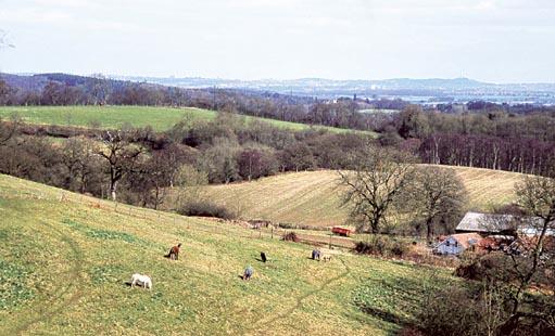
Not far north of Bewdley Wood is Trimpley Common, divided into two parts which lie either side of Trimpley Farm. The common is a mixture of woodland and grassland, studded with reedfringed pools, and it’s well worth exploring. Just to the east of it is Habberley Valley, a beautiful patch of heathland and woodland with sandstone outcrops, managed as a nature reserve by Wyre Forest District Council and always open to the public.
Although it’s not actually on the walk route there is more access land close by. This is Wassell Wood, another Woodland Trust property, reached by a short detour from the route at Trimpley.
Other things to look out for include miniature, long-haired Bagot goats at Bite Farm. As for wildlife, this is a particularly good area for birds of prey. Look for an information panel at Habberley Valley if you would like to know more about those species which are present.
FACT FILE
Start: Bewdley Bridge, grid ref SO786754.
Length: Eight miles/13km.
Maps: OS Explorer 218, OS Landranger 138.
Terrain: Mostly pasture and commons, quite hilly.
Footpaths: Excellent.
Stiles: 17.
Parking: Bewdley.
Buses: On Sundays/bank holidays the 300 goes direct from Worcester to Bewdley, but on weekdays it’s necessary to change to the 2 or 292 (or 297 to Trimpley) at Kidderminster; worcestershire.gov.uk/bustimetables or 01905 765765.
Refreshments: Bewdley.
DIRECTIONS
1 Cross Bewdley Bridge, turn left then fork right on a footpath.
Shortly fork left, going to the far left corner of a caravan park, and turn left along Northwood Lane.
Take a footpath on the right after 200 metres, walk under the railway and go diagonally left across fields.
The route is obvious, except in the final field, where you should keep close to the right-hand fence. Climb a stile in the corner, proceed to Crundalls Lane and turn left, soon passing Bewdley Wood.
2 When the lane bifurcates, take the right-hand branch, which is also a bridleway. Follow it through Hall’s Farm and on to Hillcrest, where you can take a short track on the left which leads to a footpath. Turn right along a field edge then go diagonally across three fields. Join the Bite Farm access road and follow it to the right. After passing through the farm gate you can go either straight on or diagonally left across Trimpley Common to the road. Turn left, then soon left again at a junction.
3 Take a footpath to Trimpley churchyard. Leave the churchyard at the far corner, walk to Trimpley Lane and turn left.
Turn right when you come to a footpath which is also the access road to Park Atwood Clinic. Ignore a branch path to Park Atwood Farm and continue towards the clinic, where the path turns sharp right. Follow it to Bridgnorth Road (A442).
4 Turn right, then soon right again on a footpath. Walk along a valley, to the right of Honey Brook, ignoring a path branching left at a footbridge. Continue to a second footbridge before crossing the brook. Proceed to a stile, beyond which you’ll see two further stiles. Cross the first one, on your left, and walk along a green lane to meet a track. Turn left, signed ‘Habberley Valley Circular Walk’. Go straight on at the first bridleway junction but turn right at the next one and walk to a road.
5 Turn right, then take a path on the left. Descend a flight of steps into Habberley Valley then keep left, along the valley side, at a second flight of steps which descends right. Proceed to another junction and turn right, then soon left, when the path becomes rocky.
This takes you to a large rock outcrop (Pekket Rock) where you can descend to join the main track running through the valley. After passing vehicle barriers proceed across a clearing, passing a visitor centre (summer only) before turning right at a major junction.
There should be a rustic fence on your left and very soon a large house on your right. The path climbs out of the valley, continuing straight across a field.
6 Proceed to Trimpley Common, walk to a road and turn left. Go straight on at a crossroads, rejoining Hall’s Farm Lane. Pass Hillcrest again and continue to Hawthorns to take a path on the left. Walk through a paddock then down through sheep pasture, keeping to the left of a line of wooden pylons. Cross a stile in a hedge then turn right along a field edge. Continue along the next field edge to a corner then keep straight on across the field to the far side.
Turn right in the next field and descend to Lightmarsh Farm.
7 Briefly join the farm lane before the path takes to the fields again on the right, as you draw level with a bungalow. Rejoin the lane quite soon after passing a knoll crowned by Scots pines.
Continue to a junction and turn left, then soon right, opposite Grey Green Farm. Take the first path on the right and go diagonally left across a field to the top corner before descending to cross the railway and enter Bewdley.
See the countryside in all of its beauty A walk which takes in woods, commons and stunning scenery is one not to be missed, as Julie Royle reports
Please note this walk has been carefully checked and the directions are believed to be accurate at the time of publication. No responsibility is accepted by either the author or publisher for errors or omissions, or for any loss, accident or injury, however caused.


Comments: Our rules
We want our comments to be a lively and valuable part of our community - a place where readers can debate and engage with the most important local issues. The ability to comment on our stories is a privilege, not a right, however, and that privilege may be withdrawn if it is abused or misused.
Please report any comments that break our rules.
Read the rules hereComments are closed on this article