
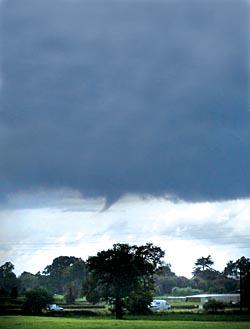
IT was the moment the start of a tornado developed above Worcester.
As rain lashed the city, the funnel cloud developed near Ombersley and quickly headed for the north of the city.
The event was captured by Worcester News reader Alan Davies, who was at home in Claines when he spotted the funnel cloud in the sky at 4.45pm on Tuesday.
"I was looking out of my bedroom window when I spotted the mini tornado," said Mr Davies. "I have seen one before so I knew what I was looking at and my first thought was to take a photograph of it. It was quite spectacular."
The bizarre phenomenon is the latest in strange weather conditions to hit Worcestershire. Following the warmest and one of the driest Aprils on record - with temperatures in the county reaching a sizzling 24.6C (76.2F) - May has been plagued with heavy rainfall.
Downpours have been so torrential that Malvern was named as the wetttest place in the country at the beginning of this week - with 33mm in the 24 hours to 7pm on Monday.
By stark contrast, Pershore was the hottest place in the whole of Britain yesterday at 17C (62.6F).
Worcester weatherman Paul Damari said: "We have seen a month's rain fall in 24 hours. All of these weather conditions are down to global warming and this is something we are going to have to start getting used to."
Mr Damari said the funnel cloud was the beginning of a tornado and it had developed under an active thunder cloud, known as a cumulonimbus, to the west of Ombersley and travelled east before disappearing.
He said: "This is known as a funnel cloud and develops underneath an active storm cell. The part that comes down is a tuba, named after the brass instrument.
"If the tuba had grown and rotated to reach the ground it would have then become a tornado and could have caused a lot of damage. Fortunately, the conditions were not quite right and this did not develop into a tornado as it did not reach the ground and passed over."
Mr Damari said tornadoes were more common in Britain than most people thought, but many go unnoticed in the countryside.
He added: "What causes this funnel cloud is when the warm air rises underneath a storm cloud and forms an active convection cell.
"As it rises, winds from the top of the storm rotate at high speed and the air begins to flow inwards and move downwards creating this narrow tuba. Pressure in the vortex causes water vapour to condense, which makes the funnel visible."
Another tornadic cloud was also spotted in Leicestershire, about 30 minutes after the one spotted in Worcestershire.


Comments: Our rules
We want our comments to be a lively and valuable part of our community - a place where readers can debate and engage with the most important local issues. The ability to comment on our stories is a privilege, not a right, however, and that privilege may be withdrawn if it is abused or misused.
Please report any comments that break our rules.
Read the rules hereComments are closed on this article