
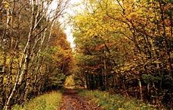
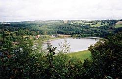
Wyre Forest is increasingly popular with walkers and cyclists but most do tend to concentrate on the area around the visitor centre. This walk explores more peaceful parts of the forest around Pound Green and Hawkbatch, where you have a very good chance of encountering fallow deer. It also includes Seckley Wood, where there is an excellent viewpoint overlooking the River Severn, Upper Arley and Trimpley Reservoirs.
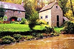
Pound Green originated as a squatters' settlement in the forest, where people once scraped a living by raising livestock, producing charcoal and coppicing trees for small timber which could be used to make tools, agricultural implements and pit-props, among other things. Today, there are expensive-looking houses clustered around a large green, and also a further scattering of cottages on nearby Pound Green Common, a lovely place which may be freely explored on foot.
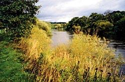
It's a mixture of woodland and grassland, with bracken, gorse and heather. Look out for green woodpeckers here - it's an ideal habitat for them. Other attractive birds which you may see on this walk include kingfishers, dippers and grey wagtails, which frequent Dowles Brook.
PLEASE NOTE This walk has been carefully checked and the directions are believed to be accurate at the time of publication. No responsibility is accepted by either the author or publisher for errors or omissions, or for any loss, accident or injury, however caused.
FACTFILE
Start: Bewdley Bridge, grid ref SO786754.
Length: 9 miles/14.5km.
Maps: OS Explorer 218, OS Landranger 138.
Terrain: Woodland, plantation, riverside meadows, common land; a few slopes but no real hills.
Footpaths: Excellent.
Stiles: 10.
Parking: Bewdley (or Hawkbatch - see map).
Public transport: First 300 goes direct from Worcester to Bewdley on Sundays but on weekdays you need to change at Stourport or Kidderminster (services include 293/294/303/2/292/11/12); Traveline 0870 608 2608 or www.worcestershire.gov.uk/ bustimetables Refreshments: Bewdley.
DIRECTIONS:
1 Walk upstream beside the River Severn on the North Worcestershire Path. After a little over two miles you will have rounded Folly Point and should look for a path branching left into Seckley Wood. Follow it uphill to a junction and go left, still uphill.
2 Pass several houses hidden behind a hedge and look for one with a satellite dish on the roof and a greenhouse in the garden. Take a narrow unsigned path on the right, opposite the greenhouse, just after a concrete post with blue paint on it. The path soon widens and is easily followed. Keep straight on at a junction, joining a bridleway. At an unsigned junction go right to find a bench at a viewpoint and then take a path leading past another bench. Walk along the top edge of a steep slope, forking right at a junction to keep close to the edge for a while before the path bears left to rejoin the bridleway. Climb to a junction, turn right past a bench then a few paces further on go right again to return to the cliff top and another viewpoint, with picnic tables. Continue along the path to a junction at the edge of the wood, marked by yellow arrows.
3 Take the second right, go left at a waymarked fork and shortly cross a stile to a field. Follow the left-hand edge, soon joining the remains of a green lane. Keep straight on past a farm to a junction and turn left to a road. Turn right and cross to a footpath. Go to the far right corner of a field then cross a stile to Pound Green Common. Go roughly straight on, passing an ash tree then walking through gorse and heather to meet a path. Turn right. At a waymarked junction turn left on a track and walk to Rose Cottage. Continue a few paces to a small wooden shed then turn sharp right on a grassy path. Keep straight on at a junction.
4 Reaching another junction near a cottage, cross a track to a narrow path opposite. Go forward into woodland, keep straight on at a waymarked junction, cross a boardwalk and then turn left at another waymarked junction. The path runs above a brook to come to a waymarked T-junction. Turn right, shortly crossing a stile beyond which the path forks - go left, up a bank to join a wide forest track. Turn left.
5 Take a path on the left just before a bend in the track, leading into conifers. Very soon there should be fields and a cottage on your left. Fork left at a junction by a stile, staying by the woodland edge until eventually you are forced to turn right into conifer forest, which soon gives way to beechwoods. Turn left at a T-junction, and then, when a house comes into view ahead, turn left at a cross-path. Go straight on at all subsequent junctions, soon leaving the trees by a house called Forest End. Walk along a track to a cluster of houses at Pound Green and proceed to a lane.
6 Turn right, then very soon left on an unsigned track. Turn right at Woodhouse Farm, soon entering a field and keeping to the left-hand edge to find a stile to the forest. Go straight on at all junctions until you come to a T-junction. Turn right and walk past Hawkbatch car park to a road (B4194).
7 Turn right for a few paces then cross to a hedge gap giving access to Withybed Wood. Turn right, then left at a fingerpost and straight on when you meet a track. Keep straight on at three more junctions. Eventually, a steep descent leads to a bridleway bounded by a traditionally laid hazel hedge. Turn left here. After three-quarters of a mile the bridleway crosses Dowles Brook, then continues beside it for a while to a junction with Drymill Lane. Turn right, climbing uphill along the lane and following signs for Bewdley at all junctions. Join a footpath when you come to Yew Tree Lane and head downhill into Bewdley.


Comments: Our rules
We want our comments to be a lively and valuable part of our community - a place where readers can debate and engage with the most important local issues. The ability to comment on our stories is a privilege, not a right, however, and that privilege may be withdrawn if it is abused or misused.
Please report any comments that break our rules.
Read the rules hereComments are closed on this article