
PEOPLE will soon be able to stroll along a new trail highlighting the hidden history of Northwick, Worcester, thanks to a £50,000 grant.
The self-guided trail will encourage people to discover more of the area's heritage, including the sites of a moated medieval bishop's palace, fishponds, brickworks, 18th century parkland, country houses, and a trading wharf on the river Severn.
The trail, funded by the Heritage Lottery Fund, will lead through the riverside nature reserve out into open country and back through the suburbs of Worcester.
Deborah Overton, from Worcestershire Historical Environment and Archaeology Service, and Sheena Payne, from Worcester City Museum and Archaeology Service, will be managing the project with help from co-leaders of the Worcestershire Young Archaeologists' Club.
Mrs Overton said: "Worcester is packed with history and archaeological sites but the Northwick area has many hidden aspects of heritage that most residents and visitors don't know about.
"We hope that the new heritage trail will help draw attention to these fascinating sites, the knowledge of which otherwise is in danger of being lost."
Heritage Lottery Fund regional manager Anne Jenkins said: "This new trail will encourage people to discover some of the forgotten elements of their local heritage and how they shaped the area of Northwick today."
The area is home to a medieval manorial landscape once owned by the Bishops of Worcester which later formed part of the local brickmaking industry.
It is hoped local people will get involved in creating signs and literature for the trail through a series of events, training, and workshops. Schoolchildren and members of Worcestershire Young Archaeologists' Club will also record oral histories as part of the project.
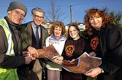
The Heritage Lottery Fund cash will also pay for the preservation of a rare map by 18th century cartographer John Doharty.
The map will be digitised to provide a useful source of information for those researching family history. It provides details on plots of land such as the name of the landowner, tenant, agricultural use and value.


Comments: Our rules
We want our comments to be a lively and valuable part of our community - a place where readers can debate and engage with the most important local issues. The ability to comment on our stories is a privilege, not a right, however, and that privilege may be withdrawn if it is abused or misused.
Please report any comments that break our rules.
Read the rules hereComments are closed on this article