
THIS high-level Cotswold walk offers panoramic views and is very easily followed, thanks to a simple route and wellmaintained paths. It links two notable honeypots, Broadway and Snowshill, which are more enjoyable at this time of year, without the crowds and congestion of summer.
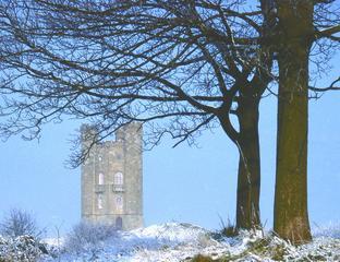
The first stage of the walk is on the Cotswold Way, which climbs Broadway Hill to the tower on its top. The tower was designed in 1799 by James Wyatt for the sixth Earl and Countess of Coventry, who lived at Croome Court, near Pershore, but also owned Springhill Estate at Broadway.
The view from the top of the tower includes Croome Court and is claimed to embrace at least 12 counties on a clear day. There is an entrance fee for the tower, but the view from the Cotswold Way at the foot of the building costs nothing and is almost as good.
Leaving the Cotswold Way, the walk continues towards Snowshill along a lane called Buckle Street, which is often described as a Roman road but was probably already ancient when the Romans arrived in Britain. It’s typical of the ridge-top routes favoured by prehistoric travellers, who shunned wherever possible the difficult and dangerous conditions found in the woods and swamps of the valleys.
There are several tumuli beside Buckle Street (at Snowshill, Willersey and Saintbury, for example) which testify to its prehistoric origins. The tumuli near Snowshill have been excavated, yielding a number of Bronze Age artefacts which are now kept at the British Museum.
Snowshill is well-named for it can be very cold in the winter. Shunning the shelter of the valley, its stone cottages cling to a steep slope beneath the bleak, exposed tops of Oat Hill and Blackoat Hill.
It’s located close to the halfway point of the walk and is a good place to take a break, perhaps at the Snowshill Arms. If Snowshill Manor is open, it’s well-worth the short detour required to visit it. A beautiful 15th-century house, it once belonged to Catherine Parr, the sixth wife and widow of Henry VIII.
FACTFILE:
Start: High Street, Broadway, grid ref SP095375.
Length: Seven miles/11km.
Maps: OS Explorer OL45, OS Landranger 150.
Terrain: Mostly sheep pasture, with some arable and woodland; there is about a mile on a quiet lane; there are two moderately steep ascents and one quite steep but short descent.
Footpaths: Excellent.
Stiles: Four.
Parking: Broadway.
Public transport: Bus or train to Evesham then Castleways 559 to Broadway, Mon-Sat only; worcestershire.gov.uk/bus timetables or 01905 765765.
Refreshments: Broadway, Snowshill and Manor Farm.
NB: There is a charge to enter Broadway Tower Country Park but this does not apply to walkers passing through on rights of way. The park may be closed in winter but again this does not affect walkers using rights of way.
There is an entrance charge for Snowshill Manor, except for National Trust members.
For opening times consult nationaltrust.
org.uk or call 01386 852410.
DIRECTIONS:
1Walk up the High Street until you can leave it on the right on the Cotswold Way, which is easily followed up Broadway Hill to the tower. Leave the Cotswold Way and follow another path to the country park entrance. Turn right along a quiet, tree-lined lane (Buckle Street) and go to the right at two junctions.
2Join a bridleway on the right soon after passing the second road junction. Follow a stone wall to a hunting gate and then go diagonally left across a field. Pass through another gate and stay on the bridleway until a footpath branches left by a wall. Follow it to a road and turn right. Keep straight on at a crossroad, into Snowshill.
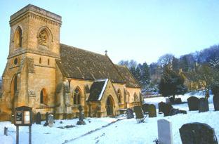
3Pass to the left of St Barnabas’ church then turn left by the Old Forge. Pass Oat House then take a footpath on the right which undulates through fields and copses before climbing to meet a track on Laverton Hill. Turn right. Keep straight on past Buckland Wood at a junction and you’ll soon find you’re back on the Cotswold Way, which joins the track from the left near Manor Farm. Follow the Cotswold Way down to Broadway.
Worcester News recommends the use of OS Explorer Maps, your ideal passport to navigating the countryside. This walk is based on OS Explorer OL45.
Please note this walk has been carefully checked and the directions are believed to be accurate at the time of publication. No responsibility is accepted by either the author or publisher for errors or omissions, or for any loss, accident or injury, however caused


Comments: Our rules
We want our comments to be a lively and valuable part of our community - a place where readers can debate and engage with the most important local issues. The ability to comment on our stories is a privilege, not a right, however, and that privilege may be withdrawn if it is abused or misused.
Please report any comments that break our rules.
Read the rules here