
Hartlebury Common is a lovely place to explore on foot, especially in August, when the heather is in flower. It's also one of Worcestershire's most important nature reserves because much
of it is lowland heath, one of our rarest habitats.
Lowland heath occurs in areas of impoverished, acidic soil, which may be dry and sandy or wet and peaty. It's characterised by sparse grasses and dwarf shrubs such as heather,
and is a man-made habitat, created in the Iron Age when woodland was cleared for settlement and agriculture. It was maintained in later centuries by people exercising common rights, including grazing and firewood collecting. But changes in land use and society
caused a massive decline which began about 200 years ago; today, only tiny remnants of lowland heath survive. Even those are threatened, with developers wanting to build on them, and some members of the general public dumping rubbish on them. Added to that,
lowland heath self-destructs when left to its own devices. It is rapidly colonised by broom, bramble, bracken and pioneer tree species such as oak and birch. Eventually, it reverts to woodland, which can't support the highly specialised wildlife which relies
on lowland heath. Species which were once widespread, from the green tiger beetle to the nightjar, are now scarce throughout the UK.
Fortunately, the importance of Hartlebury Common is recognised by its owner, the county council. Nevertheless, when the government agency Natural England carried out an assessment
in 2009 it found the common to be in 'unfavourable' condition. The council initiated a restoration programme which included tree and scrub removal, re-seeding of heather, fencing repairs and rubbish removal. There was some local opposition at the time, mainly
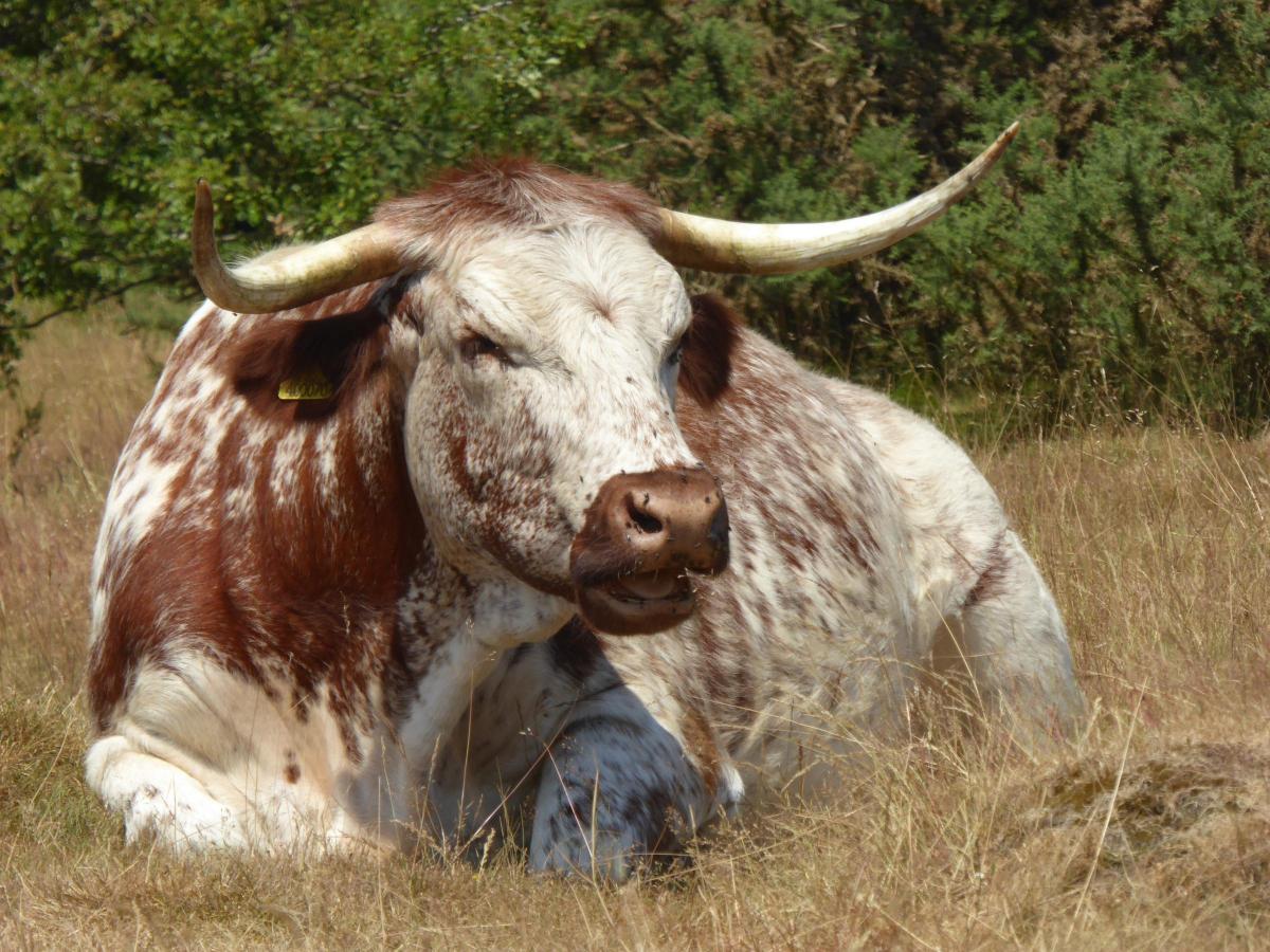
to the removal of mature trees, but there was also plenty of support, and much of the work was done by volunteers. To keep the revitalised heath in good shape, the council re-introduced grazing, employing a small herd of English longhorn cattle. The new residents
set to work, devouring invasive shoots, seedlings and saplings, and trampling bracken. When Natural England carried out another assessment in 2016 much of the heath was declared to be in 'favourable' condition. Volunteers from Hartlebury Common Local Group
work with the council (and the cattle, of course) to keep it that way.
Some walkers are nervous of cattle but the English longhorn is a docile breed, ideal for a site heavily used by people and dogs. It was developed by Robert Bakewell, who was born
into a farming family near Loughborough in 1725. As a young man he travelled extensively on the continent to learn about other farming methods. When he took over the family farm in 1760 he put into practice what he had learned, and also experimented with his
own ideas. His biggest innovation was the use of selective breeding to create livestock with desirable traits. His English longhorn remained popular until the late 19th century, when changes in farming practice led to a century of decline, pushing
it to the brink of extinction. In the 1970s, however, Joe Henson (father of Adam Henson of BBC Countryfile) founded Cotswold Farm Park and the Rare Breeds Survival Trust, and the English longhorn was saved. Today, it's in demand for its services to conservation
and may be seen on nature reserves throughout the UK.
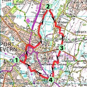
FACTFILE
Start: Stourport Bridge, Stourport-on-Severn; grid ref SO 807710.
Length: 5½ miles/8.8km.
Maps: OS Explorer 218, OS Landranger 138.
Terrain: Canal and riverside towpaths, woodland, heath, grassland, arable; flat, except for two brief slopes.
Footpaths: Excellent, apart from one which is impassable, requiring a brief detour.
Stiles: None.
Parking: Stourport Riverside.
Buses: Coniston Coaches 294/296 from Worcester, Mon-Sat; bustimes.org or Traveline 0871 200 2233.
Refreshments: Fair choice at Stourport; canalside pub, the Bird in Hand, near Leapgate; Premier Stores near Lower Heath.
DIRECTIONS
1 Head for the canal basins, either by passing under Stourport Bridge or walking past Ye Olde Crown Inn, and then following the Severn Way past the funfair to the basins. Take any route
through the site (there's lots to see, whichever way you go) but end up by joining Mart Lane on the other side of the Tontine. Proceed to York Street to join the canal towpath opposite Blossom's Tea Rooms.
2 Leave the towpath just before Oldington Bridge, joining a bridleway (unsigned) which leads to Wilden Lane. Turn right, then left onto Bigbury Lane. You should then be able to join a footpath
which runs uphill through woodland and is accessed from a short track between houses. However, the first few metres of the path, between the end of the track and the start of the wood, are so overgrown that it is impassable. So walk up Bigbury Lane instead,
until you find an unsigned path on the right. Follow it through the wood to Wilden Village Cricket Club. Go straight on, along the edge of the cricket ground. Go left in the corner, through a gate and along a field-edge path, until another gate gives access
to the adjacent field. Go diagonally across to Wilden Top Road and turn right.
3 Cross Hartlebury Road to Hartlebury Common and go straight on, close to the left edge of Upper Terrace. Keep straight on when a fence on your left turns a corner, and you see a post bearing
multiple waymarks. Turn right when you meet a wide, sandy path. Follow it to an oakwood, with a view over Lower Terraces. Look to the left to see a junction below, where Sandy Lane branches off Worcester Road. That's your objective, so keep it in mind as you
turn left, descending to Lower Terraces at any suitable point. Head for the exit gate, which is left of the road junction, near Premier Stores.
4 Cross Worcester Road, turn right, take Sandy Lane but leave it immediately for a footpath which crosses Lower Heath, going diagonally to the far left corner. Turn right to a housing estate,
cross to Britannia Gardens then turn right past Globe Cottage to find a footpath. Follow it to the river Severn, then turn right to Stourport.
PLEASE NOTE This walk has been carefully checked and the directions are believed to be accurate at the time of publication. No responsibility is accepted by either the author or publisher
for errors or omissions, or for any loss, accident or injury, however caused.
© Julie Royle 2018.


Comments: Our rules
We want our comments to be a lively and valuable part of our community - a place where readers can debate and engage with the most important local issues. The ability to comment on our stories is a privilege, not a right, however, and that privilege may be withdrawn if it is abused or misused.
Please report any comments that break our rules.
Read the rules here