

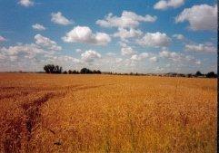
Blocking Anticyclones
The upper jet stream swirls around the temperate zones of our globe and depending on the pattern that jet stream is in, determines where the higher or lower pressure predominates. Blocking anticyclones diverts the normal track of in coming low pressure systems. Once clicked into a this mode, the blocking situation can go on for a week, a month or even a season, bringing us prolonged spells of dry weather. High pressure is a region of subsiding air, this creates an inversion, a stable layer of air with a reversal in temperature. Instead of the temperature falling with height it rises, therefore cloud cannot develop to such a vertical depth to create rainfall. Around the perimeter of the high, we often see stable delicate clouds such as small or fair weather cumulus, stratus or stratocumulus. Within the centre of the high we experience fine weather with clear skies especially in summer. In autumn or winter we can get fog and low cloud, we call the low cloud anticyclonic gloom.Blocking high pressure when locked throughout the atmosphere can stay there for long periods of time, and depending on the time of year can bring unusual lengthy spells of certain weather.
1911, 1959, 1976 it brought prolonged summer heatwaves and dry weather.
1946/47, 1962/63 prolonged severe winters.
Due to the blocking high being situated somewhere else, autumn and winter 2000, 2001 brought heavy rain and flooding, and the summer just gone torrential rains and flooding, with persistent active low pressure systems steaming into the British Isles. Over the past few months the blocking high returned, bringing dry warmer late summer weather.When the British Isles lies beneath these blocking anticyclones, the low pressure often moves north across Greenland, Iceland and down into Scandinavia, also into the Med.
Next Week......Forecasting the Weather.The answer to last week's question was: Persistent High Pressure Zone.This week's question:
Does a Blocking High over Britain bring:A/ Wet Weather.B/ Dry Weather.Good Luck.Glossary of Common Weather Terms: Stratosphere: The region of the upper atmosphere above the tropopause. No weather is found there.Weather for period Monday 17th September-Friday 21st September Northerly winds early in week will be replaced by the Atlantic Westerly through the week.Monday sunshine and a few showers, cold clear night.Tuesday fine and pleasant followed by clear, cool night.Wednesday sunshine and then some wind and showery rain.Thursday fair and pleasing.Friday sunshine and scattered showers.Maximum temperature 17-19c 63-66f.Minimum temperature 5-8c 41-46f.Last week's observations (Monday-Sunday)Highest day temperature.........23.0c 73f on Thursday 13th September.Lowest night temperature.........4.7c 41f on Friday 14th September.Wettest day...........................Trace on Sunday Night 16th September.


Comments: Our rules
We want our comments to be a lively and valuable part of our community - a place where readers can debate and engage with the most important local issues. The ability to comment on our stories is a privilege, not a right, however, and that privilege may be withdrawn if it is abused or misused.
Please report any comments that break our rules.
Read the rules hereComments are closed on this article