


THE city’s latest coronavirus ‘hotspots’ with the highest number of new infections have been revealed - with one area seeing a huge increase.
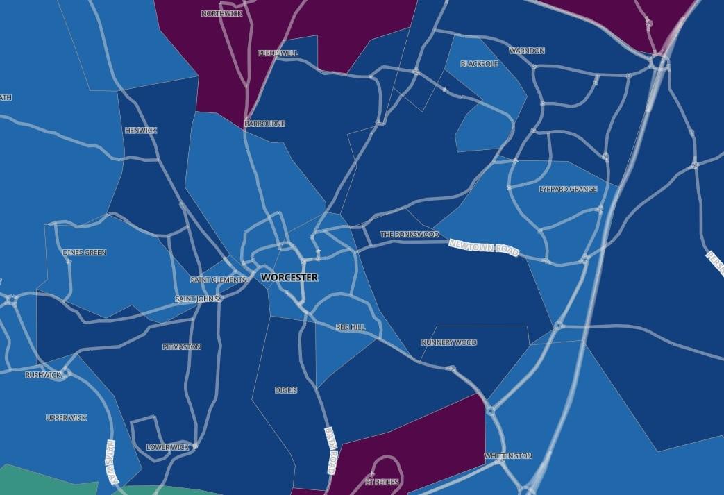
A total of 39 cases were recorded in Northwick during the week up to November 7 – the most in any area of the city - and 30 cases were recorded in bordering Fernhill Heath and Ombersley.
Twenty six cases were recorded in Barbourne and Rainbow Hill during the week with 25 cases recorded in Ronkswood and Nunnery Wood.
A total of 23 cases were recorded in St Peter's and 20 cases were recorded in Warndon East.
Nineteen cases were recorded in King George’s Field - which covers WR3 and WR4 postcodes including parts of Astwood Road, Tolladine Road, Langdale Drive, Brickfields Road and Blackpole Road – during the week.
A total of 18 cases were recorded in Battenhall and Diglis and 17 cases were recorded in Lower Wick and Bromwich Road.
A total of 14 cases were recorded in Worcester Town North - which covers most of the city centre towards Worcester Cathedral as well as Sidbury, parts of London Road, Wyld's Lane and Lowesmoor.
A total of 13 cases were recorded in Worcester Town North - the area covering many WR1 and some WR3 postcodes and includes most of the city centre, Arboretum and Barbourne. Seven cases were also recorded in Battenhall and Diglis.
Twelve cases were recorded in both Lyppard Grange and Henwick.
Nine cases were recorded in Warndon West.
The figures are split into several ‘middle super output areas’ – which is used by the Office for National Statistics (ONS). These zones are slightly larger than postcode areas with an average population of around 7,200 people.
The latest data published by Public Health England shows which areas in Worcestershire have recorded three new cases or more between November 1 and November 7.


Comments: Our rules
We want our comments to be a lively and valuable part of our community - a place where readers can debate and engage with the most important local issues. The ability to comment on our stories is a privilege, not a right, however, and that privilege may be withdrawn if it is abused or misused.
Please report any comments that break our rules.
Read the rules hereLast Updated:
Report this comment Cancel