
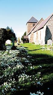
The church of St Mary Magdalene at Little Hereford, near Tenbury, is of considerable interest in itself, but from late January to mid or late February it has the added appeal of a churchyard full of snowdrops.
There are wild daffodils too, in bloom for a few weeks from early February onwards.
The church stands in a field by the river Teme, aloof from the village which straggles along a road.
However, Little Hereford used to be bigger than it is today - the Domesday Book records five watermills there - and some minor earthworks east of the church may indicate the site of the original village.
Between the church and the river a prominent mound and a ditch mark the site of a fortified, moated, mediaeval manor house.
DIRECTIONS1 Walk along Market Street then turn right at the Market Tavern to the church. Join a footpath at Chantry Close, left of the churchyard entrance. Follow it to a sheltered housing development, walk straight through then turn left at the far side to find a footpath on the right. Cross a field and turn left along the edge of another to a gate. Go straight on to Berrington Road and turn right. Keep straight on at two junctions (Morningside and Haresbrook Lane).
2 Cross Bednal Bridge then take a footpath on the right. Walk across a sloping field to the far right corner then continue along the edge of a tree nursery. Keep straight on until you can turn left between buildings to a lane. Turn right, then soon left on a bridleway to Berrington Mill House. As you approach the mill, cross a stile on the right, climb up a wooded bank to an orchard and turn right. Walk to a lane and turn left to reach a T-junction at Lower Town.
3 The next right of way begins across the lane, going past Brook Farm then turning right across a field to the far side, then left by the edge. However, given the lack of waymarking, and the daunting access, some walkers turn right along the lane to the last barn on the right then go through the gate opposite and walk up the right-hand field edge, joining the right of way after about 50m. The path stays by the hedge all the way to a gate giving access to Field Lane, but at one point it is blocked by a fence armed with barbed wire. It's not hard to cross, but if you expect difficulties you may prefer to use the lane instead, all the way from the T-junction (see map).
4 Take another footpath almost opposite (assuming you have used the footpath from Brook Farm). Cross an orchard and a field to a lane. Continue opposite, going to the far left corner of a large pasture, then along a cliff-top until a waymark directs you down to the Teme. Follow the river to a footbridge which gives access to the church at Little Hereford.
5 Re-cross the footbridge and walk straight across the field to a slope, about 100m to the left of a farmhouse. A track climbs gently uphill and you can join this for a short distance until the right of way heads straight up - look for a very faint path leading to a stile at the top. Walk across an orchard to a lane, cross to a bridleway opposite and go along the left edge of a field then through a green gate. Turn left on a footpath (no waymark) by the hedge. Keep straight on along the edge of another field until the hedge turns a corner. Continue across the field, to a gate opposite the right-hand end of farm buildings on the other side of Field Lane (this path has been re-routed and is not as shown on the latest edition of OS Explorer 203).
6 Turn left past Field Farm then take a path on the right. Go to the far left corner of a field, and then along a good path running through fields, a private nature reserve and a young wood. Meeting a lane, take a path opposite, going along the edge of an orchard to return to Berrington Mill. Go straight on, past kennels, then left across Cadmore Brook to follow another good path to a lane. Turn right, then left at a junction. Re-cross Bednal Bridge when you come to it, then take a path on the left. This has also been slightly re-routed, but is easily followed. It begins as a woodland track, then continues along a field edge to a stream, beyond which it climbs to the cliff-top, from where it's an easy stroll back to Berrington Road and Tenbury.
FACT FILE Start: Tenbury Wells, grid ref SO596683.
Length: 6 miles/10.5km.
Maps: OS Explorer 203, OS Landranger 137 or 138.
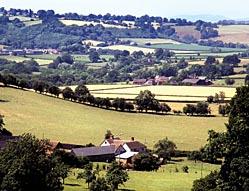
Terrain: Mostly level, but with a few slopes. Pasture and orchard, with some road walking, but traffic is light.
Footpaths: Most are all right, a few are excellent but some are dreadful, with signage and waymarking either patchy or absent. One path not only lacks any signage but is also obstructed with barbed wire. Another is similarly obstructed, with a fence across it, but there's an alternative route (if this is an official diversion, there's no indication of the fact). There are two dodgy gates, each hanging perilously from one hinge. On the approach to Berrington Mill the noise of a pack of barking dogs may be intimidating so it's useful to know they're locked up and not running loose.
Stiles: 30, plus two fences and probably some gates.
Parking: Tenbury.
Buses: Yarrantons' 758, Mon-Sat; www.worcestershire.gov.uk/bustimetables or Worcestershire Hub 01905 765765.
Refreshments: Tenbury.
PLEASE NOTE This walk has been carefully checked and the directions are believed to be accurate at the time of publication. No responsibility is accepted by either the author or publisher for errors or omissions, or for any loss, accident or injury, however caused.


Comments: Our rules
We want our comments to be a lively and valuable part of our community - a place where readers can debate and engage with the most important local issues. The ability to comment on our stories is a privilege, not a right, however, and that privilege may be withdrawn if it is abused or misused.
Please report any comments that break our rules.
Read the rules hereComments are closed on this article