
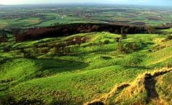
Bredon Hill is modest in height, reaching only 299m, but the lack of competition in low-lying south Worcestershire enables it to make an impact on the landscape out of all proportion to its size.
It's important in other ways too, with parts of the scarp slope and summit included in a national nature reserve, a designation bestowed on only the very best sites.
The nature reserve includes treasures such as a diverse and colourful limestone flora and a number of veteran oak and ash trees which dot the northern slopes.
They support a wide range of wildlife including the engagingly named violet click beetle which has so far been discovered in only two places in the country - the other is Windsor Great Park.
Further uphill, the oaks and ashes give way to numerous hawthorns, which look spectacular when in flower. Fallow deer live on the hill and although they're shy it isn't uncommon to see them, albeit briefly before they make a run for it.
The view from the top is panoramic and on sunny days it's a great place for a picnic.
Open access is permitted to the land around the highest point, which includes the earthworks of a hillfort built during the Iron Age.
This public access is granted as part of a Countryside Stewardship Scheme and will end in September 2010, unless the agreement is renewed. Just below the ugly tower which marks the summit is a much more appealing feature, the Banbury Stone, a chunk of rock which so closely resembles a kneeling elephant that perhaps it's no wonder it has inspired various legends and curious practices.
There are stories of the elephant' descending the hill at sunset to drink from the Avon and at one time the people of the vale would climb the hill on Good Friday to kiss the stone, though no one seems to know why.
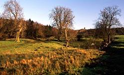
Returning to the vale, specifically the meadows north of Eckington Bridge, note that the yellow colouring on the map indicates permanent access land, so feel free to wander.
DIRECTIONS1 Follow the roadside path to Eckington and then take a footpath along the edge of the churchyard to Jarvis Street. Turn right past The Old House, walk to a junction and turn left on School Lane. Turn right at the end of the lane, joining Hacketts Lane which immediately bends to the left. Keep straight on at a junction with Stony Furlong Lane, along a 'no through road' and then straight on at a junction with Oatsley Lane, along a footpath. Ignore another path branching left and keep straight on past Upper End Farm.
2 The path takes to the fields and is mostly easy to follow. You should be heading towards a group of converted farm buildings (Deer Park Business Centre) at the base of Bredon Hill. Having crossed a footbridge into the fifth field, turn right beside the hedge and follow it as far as the second of two wooden posts then move away from the hedge, going diagonally towards a road, still heading for the business centre. As you approach closer to the road you'll see a fingerpost in the hedge and should aim for that.
3 The footpath continues opposite, going diagonally across a field to the far end of a conifer hedge, and then to a gate to a driveway. Turn left, then right. As you approach Woollas Hall, take a path leading uphill. It takes a meandering route but is well-trodden, waymarked and easily followed. Turn left at the top, following a stone wall along the escarpment rim, passing the tower, the Banbury Stone and the earthworks of the prehistoric fort.
4 Cross the wall at a stone stile, turn right to a fence and go downhill. It's very steep at first, but soon becomes easier. The path is waymarked and basically follows the fence, crossing and re-crossing it at intervals. At one point it briefly moves to the left, away from the fence, but soon returns to it. Eventually you'll join a well-defined track leading to Great Comberton. Go straight on through the yard at Manor Farm, climb over a barrier, walk past a green barn then turn left through a field to a lane.
5 Turn right, then go first left along the edge of the churchyard. Leave the churchyard in the next corner and walk to a lane. Turn right, then shortly take a path on the left (Shakespeare's Avon Way) which is waymarked and easily followed to Nafford. Turn right, pass Nafford House then take a path down to the Avon. Cross the river's twin channels at Nafford Lock then bear left to cross Berwick Brook and follow a track to Birlingham.
6 Go left at Lower End Farm, then left at the next junction and follow the lane round to the right until you can take a path on the left. Ignore another branching right, but turn left at the next junction and walk to Swan's Neck, a tight loop of the River Avon. Go into a large meadow and make your way to Eckington Bridge, using any route of your choice across the meadow.
FACT FILEStart: Eckington Bridge, grid ref SO922422.
Length: 7 miles/12km.
Maps: OS Explorer 190, OS Landranger 150.
Terrain: Close-cropped turf on Bredon Hill, pastoral and arable farmland in the vale; the ascent of the hill requires relatively little effort but there is one very steep descent, though only for about 100m.
Footpaths: Mostly excellent.
Stiles: Five.
Parking: Eckington Wharf picnic place by Eckington Bridge.
Buses: Astons 382 Worcester-Pershore via Eckington, daily; www.worcestershire.gov.uk/bustimetables or Worcestershire Hub 01905 765765.
Refreshments: Two pubs and a shop at Eckington.
Worcester News recommends the use of OS Explorer Maps, your ideal passport to navigating the countryside. This walk is based on OS Explorer 190.


Comments: Our rules
We want our comments to be a lively and valuable part of our community - a place where readers can debate and engage with the most important local issues. The ability to comment on our stories is a privilege, not a right, however, and that privilege may be withdrawn if it is abused or misused.
Please report any comments that break our rules.
Read the rules hereComments are closed on this article