
BREDON Hill dominates the vale of Evesham and needs no introduction.
Any walk on the hill is enjoyable as the terrain is varied and the views panoramic.
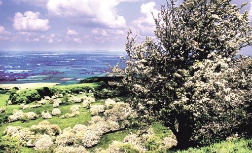
Part of the hill is a National Nature Reserve, noted for its veteran trees, mostly ash and oak.
But there are also dozens of magnificent veteran trees outside the reserve borders, on the lower slopes of the hill and in the vale.
These are mostly willow pollards, along with oaks and poplars, and you will see many of them on this lovely walk.
Some grow beside field edges while others are to be seen along the beautiful old green lanes (including a former salt way) which are such a delightful feature of the walk.
There are charming villages to explore too, such as Little Comberton and Cropthorne.
FACT FILE
Start: New Inn on B4084 at Cropthorne, grid ref SO998441.
Length: Nine miles/14.5km.
Maps: OS Explorer 190, OS Landranger 150.
Terrain: Sheep and cattle pasture, arable fields, woodland and green lanes; the climb up Bredon Hill is obviously fairly steep in places, but most of the route is through low-lying, flat country.
Footpaths: Mostly excellent. Some improvements are needed but there are no real problems.
Stiles: Eight.
Parking: Lay-by just beyond the New Inn – restricted to four hours only so find alternative parking if you think you will need longer (eg Elmley Castle picnic place is close to the route – see map).
Buses: First 550/551, frequent, Mon- Sat; both stop at Cropthorne Green, but the 551 gets there via Fladbury, while the 550 goes via the B4084 and Brook Lane (Cropthorne turn), allowing you to get off there, near the New Inn; on Sundays/bank holidays Aston’s 166 avoids Cropthorne Green but travels along the B4084 so you can get off at Brook Lane, New Inn or Smokey Lane; worcestershire.gov.uk/bustimetables or 01905 765765.
Refreshments: New Inn.
DIRECTIONS
1 Walk a short way beside the road towards Evesham then cross to Smokey Lane. Go to the end of the lane and then continue along a bridleway, which soon bends right. It leads to a field where you continue along the lefthand edge, past a line of pollarded willows and a magnificent white poplar. Keep straight on at all subsequent junctions until you come to an unsigned footpath on the right. You’ll recognise it because it starts off as a very wide track, marked by a heap of dead wood and a nettle-covered mound.
Follow the path to a farm and turn left, joining the Wychavon Way.
2 Turn right on Netherton Lane, then soon left to skirt Elmsbury Court. Cross a stile on the left, walk along a field edge, duck under an electric fence in the corner, cross a slippery footbridge and another stile and walk along a woodland edge then a field edge.
Turn right along a road then left through a gate after 200 metres.
There are two paths here – the Wychavon Way is the field-edge bridleway. Follow it uphill, guided by a succession of waymarks, eventually entering woodland (Long Plantation) near the top of the scarp slope. Keep climbing to a junction at the top.
3 Leave the Wychavon Way and turn right to walk for 800 metres along the rim of the escarpment.
Turn right at a cross-path, back into the wood, then straight on at another cross-path, leaving the wood for grassland. Follow the bridleway down, ignoring another bridleway branching right, crossing the plateau of Even Hill and then descending through woodland and plantation to return to grassland. About 400 metres after you leave the trees a footpath branches right. Ignore this, but look out for another one, just a little further on, which branches left.
4 Cross a field to the far side then continue to the far corner. The right of way goes diagonally but no path has been made and most walkers follow the field edge round to the right. Ignore another path branching left and keep going to the corner where a gate gives access to a junction with a bridleway. Go straight across, staying on the footpath, which runs along a field edge. After about 100 metres it changes to the other side of the hedge, but continues in the same direction to meet a lane.
5 Turn left to Little Comberton.
Pass Manor Lane then take a path on the right. Walk across an orchard then into a field. Go to the far left corner and keep to the left of another field. Turn left after crossing a footbridge, go through a metal gate and turn right. Walk to an easily visible gate at the far side of a field (not the one hidden in the corner). Two paths are waymarked – take the one by the left-hand hedge and then bear right when you reach a waymarked post. Walk to the far right field corner.
Continue along the left edge of the next field, and then through a paddock to meet a lane opposite Court Farm at Bricklehampton.
6 Turn right then walk straight through a churchyard, passing to the right of the church, to a field. Walk across to a waymarked post then go diagonally left to a fence corner, turn right and walk to a lane. Turn left. After about 800m, when the lane bends left, turn right on a bridleway. Leave it for a footpath when you see a yellow arrow on the left. You’re back on the Wychavon Way now and it is easily followed to the B4084, meeting it between Brook Lane and the New Inn – just don’t miss the point where the Way makes a sharp left turn, at a stile just before a metal gate.
Please note this walk has been carefully checked and the directions are believed to be accurate at the time of publication. No responsibility is accepted by either the author or publisher for errors or omissions, or for any loss, accident or injury, however caused.


Comments: Our rules
We want our comments to be a lively and valuable part of our community - a place where readers can debate and engage with the most important local issues. The ability to comment on our stories is a privilege, not a right, however, and that privilege may be withdrawn if it is abused or misused.
Please report any comments that break our rules.
Read the rules hereComments are closed on this article